News Detail
Land Subsidence Varies Across Java’s Northern Coast, Sea Level Rising up to 4.3 Millimeters per Year
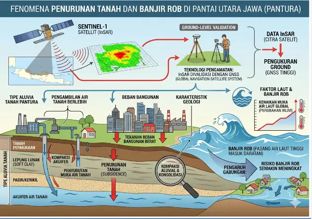
Bandung – Humas BRIN. Several areas along the northern coast of Java (Pantura) are experiencing varying levels of land subsidence while facing sea level rise of up to 4.3 millimeters (mm) per year.
This condition affects various coastal regions, including Jakarta, Bekasi, Indramayu, Cirebon, Subang, Pemalang, Pekalongan, and Demak, and may increase the risk of future coastal inundation.
Associate Researcher at the Geoinformatics Research Center (PRGI) of the National Research and Innovation Agency (BRIN), Agung Syetiawan, revealed that land subsidence phenomena along the Pantura region can be observed through various geodetic and remote sensing approaches.
The utilization of Interferometric Synthetic Aperture Radar (InSAR), Global Navigation Satellite System (GNSS), terrestrial observations, and multi-data geospatial modeling has become an important part of mapping the deformation dynamics of coastal regions.
“GNSS observation data obtained from the Indonesia Continuously Operating Reference Station (InaCORS) also show vertical deformation patterns that tend to be non-linear across most Pantura areas. These data are used to validate observations from Synthetic Aperture Radar (SAR) satellites,” Agung stated during the BRIGHTS Series #2 event on Tuesday (26/5).
He explained that groundwater exploitation is one of the main factors causing land subsidence in coastal areas. “The increasing demand for clean water by communities as well as aquaculture activities such as vannamei shrimp farming has intensified pressure on groundwater reserves,” Agung explained.
In addition, land subsidence worsens the impacts of sea level rise along Java’s northern coastline. Based on altimetry data analysis, sea level rise trends range between 2.4 mm and 4.3 mm per year.
Using a simple bath up model, several coastal areas in Pantura are projected to experience permanent inundation if proper mitigation measures are not implemented. Muara Gembong and several coastal areas in Jakarta, Tangerang, and Bekasi (Jatabek) have reportedly experienced expanding inundation areas due to the combined effects of land subsidence and sea level rise.
According to Agung, the development of mitigation infrastructure such as giant sea walls must consider comprehensive geospatial studies so that priority handling areas can be accurately determined.
He also emphasized the importance of data-driven geospatial policies in supporting sustainable coastal development, including groundwater extraction control, mangrove rehabilitation, and sea wall development evaluation. “Save water, save life. The clean water we conserve today is the breath of life for future generations,” he stressed.
Agung further noted several limitations in current subsidence observation systems, one of which is that monitoring stations are not always located directly within areas experiencing the highest rates of subsidence.
To address this issue, BRIN together with the Geodesy and Geomatics Engineering Department of the Bandung Institute of Technology (ITB) conducts episodic monitoring through the installation of permanent benchmark pillars at several land subsidence hotspots, which are monitored periodically each year.
Head of PRGI BRIN, M. Rokhis Khomarudin, stated that land subsidence and coastal ecosystem degradation are multidisciplinary issues requiring continuous support from geospatial and remote sensing research.
“The utilization of GIS and remote sensing technologies is extremely important to support monitoring, analysis, and the development of mitigation strategies based on scientific data,” he said. (ds, fa/ed:mg, tnt)